|

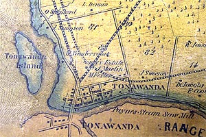
Tonawanda in 1855. View the full size original in our museum.
See another very interesting map of "downtown" -- an 1868 survey, with a scale equal to "2 chains to an inch" -- in our book. p. 14
Get our book... 
|
Historical Society of the Tonawandas has
Vertical document files
Archival photographs
Original historical items
Tonawanda
North Tonawanda
The Erie Canal
Buffalo
Western New York State
Easily accessible to museum Research Assistants, ready to help you, through an indexed computer database. (This is not currently on the Web.)
|
Erie County maps
New York State maps
Niagara County maps
North Tonawanda maps
Tonawanda maps
Sanborn Insurance Maps – 1893 to 1950
World maps
Ask us.
|